Navbar

About Us Client Login Weddings Projects Blog Home

Thursday, February 7, 2013

Sill Hill Waterfall Hike - another great San Diego County day hike!

If you can't tell yet from reading our blog, we like to hike.  Actually, we are trying to do at least one long hike a week at sunrise or sunset for the great light (for photography) and to increase our chances of encountering wildlife.  Another goal is to acclimate to wearing packs and getting used to navigating in the backcountry to prepare for a 5 (or so) day backcountry hike in the Sierras.

Our hike this week was to the Sill Hill falls near Julian, CA in the Cleveland National Forest.  We actually didn't make it to the falls themselves (more on that later), but even without reaching that goal, the hike itself was pretty incredible.  In Jerry Schad's great book Afoot and Afield: San Diego County, he describes this hike as an out-and-back along Milk Ranch Road off of the 79 highway just south of Lake Cuyamaca.  (side note: if you like to hike in San Diego you really need this book!)

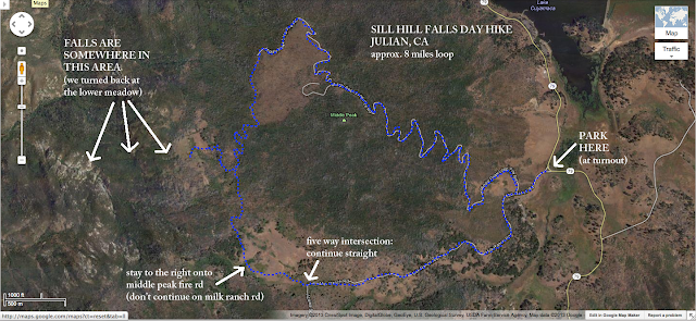
We chose a slight variation on the out-and-back hike.  We incorporated the Middle Peak fire road and did a loop around Middle Peak after approaching the falls via Milk Ranch Rd.  It increased the distance a bit for a total of about 8 miles, and increased the elevation changes (so we can strengthen our legs and lungs for the Sierras).  It's pretty easy to find your way in this area if you stick to the fire roads, but beware of private property signs - especially if you leave the roads.  The available maps and descriptions of the area that I was able to find online were somewhat lacking in detail, but you will be fine with the roads.  At the point where you leave the roads to get to the falls, you may have more difficulty in navigating, as we did.

Here's a map of the area:

Sill Hill Falls trail map

Our adventure began at 4:50am.  Time enough for us to pack up and get out to the Cleveland National Forest before sunrise.  We took I-8 from San Diego to highway 79 toward Julian.  As we approached the trailhead for Stonewall Peak, a bobcat leapt from the bushes and ran across the road.  No time to get cameras ready... but he most likely looked like this close up:


What a great way to start the day before we even got out of the car!  I've never seen a bobcat in the wild, and we held high hopes now of witnessing more wildlife on the trail.  And no, the one we saw wasn't actually a kitten - it was about the size I'd expect from an average adult bobcat.

We drove past the Stonewall Peak trailhead and reached the sweeping right curve in the road with a dirt turnout/parking area (if you get to Lake Cuyamaca - you went too far).  We parked there and shuffled across highway 79 in the faint dawn light to reach Milk Ranch Road.  It's a dirt road, gated just off highway 79, so forget trying to take your car out to the falls.  There are also quite a few warnings in the area about Mountain Lions, so be aware and keep your pets on leash and children close.

As we began our hike along Milk Ranch Road, we were pretty stunned at what the area looked like.  The Middle Peak area (and quite a bit of East County San Diego) was hit very hard by the 2003 Cedar Fire.  In fact, most of this part of the Cleveland National Forest still looks like a burned out wasteland, just over nine years later.


While this doesn't make for the best scenery for a hike, it is quite interesting to see how burn areas recover and how unpredictably fire can behave.  There are spots where groups of burned tree husks litter the ground, yet somehow an old tree survived amongst those others that were clearly engulfed in raging fire.  Considering the number of burned trees on Middle Peak, this hike would have been gorgeously green and wonderful before the fires.  Now its beauty and charm are different, but still worth the trip.

The sun began to peek over the horizon, lending a red-orange glow to the clouds and allowing us to see Stonewall Peak to the south.


We continued on, through a large group of still living old-growth trees and emerging to a large burn area to our right on the south slope of Middle Peak.  But on the left was a meadow and the sound of running water in a creek.  That's where we spotted our first mule deer of the day.  Or should I say they spotted us?


A very well fed hawk kept an eye on us as we passed the five way intersection on Milk Ranch Road.  Then we turned a corner and came upon this west-facing view!  It's kind of hazy, but yep, that is the ocean out there on the horizon - about 50 miles away.


Just after the right turn onto the Middle Peak fire road, we ran into our second group of mule deer.


And we ran into another surprise!


It rained a week before we did this hike, and the ground was still soft.  In fact it was muddy with puddles in some areas.  But these bobcat tracks were most likely from the week prior, considering how deep they were.  The ground was too hard for them to have been fresh.  We didn't include any objects for scale in this photo so you could see the size of the prints (oops!), but they were in fact quite small.  Maybe our friend from the road had been skulking about this mountain last week?

We continued going up the fire road, looking for trailhead markers for the path down to the falls.  Our research online had told us that we needed to go left (west) off the Middle Peak fire road at a barbed wire fence, and that the trailhead may be marked by a cairn and red ribbon tied to branches.  Well, along the way we saw some remnants of barbed wire fence to our left, but also saw quite a few "No Trespassing" signs.


This is not the trail your looking for.  Continue past the signs and you will eventually reach the actual trailhead for the falls.  We saw no signs of a barbed wire fence near the trailhead, but there was a nice big cairn and ribbon.


There was also a mountain lion track!  Yikes!


We had read that since the 2003 fires, the trails up here have become overgrown with brush and can be at times somewhat impassible.  That seems true, but it really depends on your comfort level with bushwhacking.  There really isn't much of a trail once you leave the fire road.  There are just red ribbons tied to branches along the way to lead you.  We went over and around dead logs, pushed through dense brush, and tramped over branches.  Luckily for us, there didn't seem to be any poison oak or poodle dog bush in the area.  At one particularly dense area of brush, someone had clearly spent some time cutting a tunnel through.  Thanks, whoever you are!


We continued down through the brush until it opened up into a small meadow.  We could see a ribbon on the far west side and made our way there.  After a short, steep descent through some mud, we reached a much larger meadow below the first.  From here, the west facing views were spectacular!  We could see all of San Diego County, including downtown, Coronado, the Miramar air field, and all of the sprawl in between.


We looked across the open meadow and saw numerous game trails.  There was no clear path.  The obvious options were to continue west down the hill, or turn north to what appeared to be a creek bed.  We chose to go north to the creek bed and then walked west along the creek.  After a few minutes of walking, we looked back and realized that we would have to walk back up the hillside regardless of whether or not we found the falls.  With the very small amount of water flowing in the creek, we thought that even if we found the falls, they probably wouldn't be too impressive.  We were having such a great time on this hike, we didn't really care about reaching the goal.  Plus, thoughts of Julian apple pie were starting to edge their way into our minds.  So we turned around and marched back up to the fire road.

Looking at the map later, it appears we were on the right track.  Just continue west when you reach the lower meadow and it looks like it runs into a gorge that must be the falls.  I'm sure we'll be back again to explore more and reach those falls!

On the way back out, Katie thought to add another stone to the cairn.


We then continued up the Middle Peak fire road and into an extremely bad burn area.  The scenery here was repetitive and ultimately became boring.  If we do this hike again, we will make it an out-and-back along Milk Ranch Road.

But there was some excitement as we found another Mountain Lion track.  Seeing this many tracks around certainly caused us to be much more attentive to our surroundings.

As we slogged our way up Middle Peak, all we initially saw were black tree carcasses.

But then we began to find signs of restoration efforts.


And snow!

There were quite a few areas on the North and East facing slopes of Middle Peak that had been freshly burned.  It still smelled like fresh BBQ.  These areas had been part of controlled burns in November 2012.


In these fresh burn areas, we ran into the dreaded poodle dog bush!  This nasty creature has hairy leaves that can cause some pretty nasty skin and respiratory irritation.  If you see this plant in the backcountry, stay far away from it!  It typically grows in recent burn areas.

As we approached the road, we ran into a few more deer friends.  They pranced through the fields.


And then, every deer in Cleveland National Forest came out to say hello.


See you later!

If you have any interest in seeing how forests recover from wildfires, or you want to do some bushwhacking, or you want to see some falls, or just be at one with nature, this is a great hike.  This hike was very secluded.  We didn't see a single person on the trail, and only a few at the parking area upon our return.  If you go out and find the falls, please drop a comment here and let us know how close we were!

-Bluescape Jay-


Wednesday, January 30, 2013

Make your own custom CD/DVD cases

We like to make custom hand made DVD cases for our photography clients.  Yes, I know that CD/DVDs are on their way out for data storage, but we still provide them.  I imagine that we will soon start giving out photos on flash drives as they are pretty darn cheap now - and then our clients will have a nice reusable gift as well.  But for now, it's DVDs.  And we make the case by hand.  Here's the proof:


So the video is pretty self explanatory and provides the needed measurements.  But I thought I'd link to the materials that we used and also add a little more information.  First off, here are the materials we used:


We first used an additional piece of the cardstock to make a template of our design.  After that, making the cuts for the actual final piece was easy.  The most difficult part in the making of the template was creating the curves in the top flap with the tab.  Katie worked hard and used curved objects in the house (like coins) to make the curves, and also did a bit by hand.  It may be easier to use a compass or stencil to make the curves, but just know that you can do it with objects around the house like cans and coins!  

We experimented with how thick we wanted the case to be.  We ended up going with a 1/2" thick case because we had planned all along for a double CD case which needed that extra space.  If you are doing a single CD case, you can probably go with 1/4" thickness (the measurement between the fold lines) unless you like the added size.

After you make your cuts, you can decide how much lace paper you want to add to the outside.  We chose to cover the entire outside except the top flap, and so cut the lace paper accordingly.  From there it was easy to apply the spray adhesive to the lace paper and attach it to the cardstock.  Be sure to use spray adhesive in a well-ventilated area and use a mask to prevent inhalation.  Seriously - getting glue in your lungs is not the secret to a long happy life!

We also added in a thank you card held in by slits cut to the card corners.  As you can see in the video, the slits were mostly measured out be placing the card in the middle of the flap and then marking diagonally across the card corners.  Pretty easy.  Then we placed the self adhesive CD hubs in the center of the flaps needed to hold the CDs.  I thought that we would need additional adhesive when I ordered these, but we didn't.  These things hold surprising well!  The 100 pack off of Amazon only cost about $9 and they are excellent.

We chose no additional decoration for the outside of our case, but we had considered using some twine or ribbon to tie it up.  We'd love to hear anyone's addition to our design, so please comment if you changed something or added additional decoration.  Have fun!

-Bluescape Jay-


Monday, January 7, 2013

If you live near San Diego County, you must do this hike!

Ok, so maybe it's not lions and tigers (or bears).  But coyotes and owls and hawks, oh my!  This is the story of our recent hike out to the Eagle Rock formation near Warner Springs, CA.  We'd actually been once before on an extremely hot summer day and it wasn't pleasant.  We decided that this time, we'd go in the winter and try to get to the trailhead for sunrise.  Well the plan worked out great this time, because we got to see quite a bit of wildlife and an amazing sunrise over the rolling hills that surround the rock formation!

For those of you who don't know about Eagle Rock, it is a a group of boulders sitting right in the middle of an open field that really does remarkably resemble it's namesake.  It's a bit of a drive from coastal San Diego, but well worth it.  It's also close enough to Julian for a post-hike slice of apple pie.

Eagle Rock
The back side of Eagle Rock

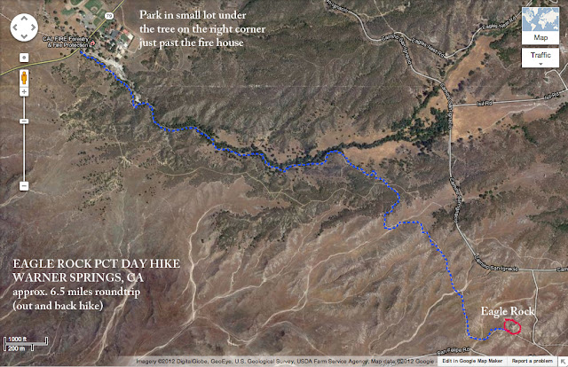
To get to the trail head from San Diego, take the 78 east past Ramona and take a left in Santa Ysabel onto the 79 north.  Continue until you reach Warner Springs.  The trailhead is right next to the small bridge you'll go over as you approach the fire station on the south end of the town.  There is a small dirt lot under a tree to park in just past the fire station on the right.  When you reach the trail head, make sure you go east off the road.  The trail goes in both directions off the road as this trail is actually a section of the Pacific Crest Trail (PCT) that travels from the border with Mexico all the way to Canada!

The hike to Eagle Rock is about 6.5 miles roundtrip (out and back).  It's an easy hike with only a few rolling hills to deal with that are not difficult.  It starts off along a creek bed surrounded by dense trees.  Later it opens up into rolling hills with desert chaparral.  Eventually you'll come across a large group of boulders on the crest of a hill.  Take the side trail here to the left to circle around the boulders and there you'll see it.  Pretty much exactly what it's supposed to be with a name like Eagle Rock!
Trail Map to Eagle Rock
My crudely drawn map of the trail to Eagle Rock
Our adventure began just after sunrise when we arrived at the trailhead.  It was cold - around 29°F!  We concluded that we are very extreme people, as the last time we'd done this trail it was over 100°F.  But we came prepared and after adding an extra layer of clothing, we were off.  The orange glow of the sun still lingering behind the hills and spilling through the trees branches allowed us a glimpse of our first animal friend of the day - a Great Horned Owl.  Unfortunately he was pretty shy and kept far enough away in the branches to prevent a good photo.  This is all we could manage:
Great Horned Owl
Great Horned Owl


We continued along the creek as the sun rose allowing for some nice photo opportunities.
Cactus in the Morning Light
Morning Glow


Plant in Morning Light
More Morning Glow


The trail then opened up into meadows, hills, and some desert brush.  One tree stood alone on the edge of this transition from tree cover to open hills.  
Barren Tree Alone on a Hill Top
Lone Tree


After about another mile, we crested a hill and saw our destination: 

As we climbed and photographed the boulders, the sun began to warm the valley.  One of us still needed their puffy down jacket though...
Katie sitting on a rock
Still cold even with the sun


The squirrels woke up and joined us in climbing all over Eagle Rock.  I think they were looking for a hand out.
Squirrel on a Rock
Squirrel Looking for Food


After enjoying a snack and relaxing for a while, we set off for home.  Just a few hundred yards from the rock formation we came across a dead ground vine that we had missed on the hike in.  Although the vine looked dead, it had some very much alive looking fruit spread around.  We thought it might be wild watermelon, but since we weren't sure, we took some photos for later identification.
Photo of a Buffalo Gourd
Buffalo Gourd


Well, it turns out these things aren't watermelons at all.  They are something called Buffalo Gourds.  They are apparently pretty gross to eat and potentially poisonous.  But native peoples used them for everything from soap to food storage (after cleaning out and drying the outer shell).  Hopefully animals like to eat them because we left a nice plump gourd cut in two!
A Buffalo Gourd cut in half revealing the inner fruit
Perhaps a Tasty Treat for a Squirrel?


On our way back we took some more photos of the trees.
A photo looking up through tree branches at the blue sky
Branches as art


As we approached the road to end our hike, Katie spotted some movement off to her right.  That movement turned out to be a rather large coyote on the opposite side of the dry creek bed.  Of course, just like Mr. Owl, he didn't cooperate for a photo.  There was just too much distance and foliage in the way.
A picture of a Coyote seen through branches and bushes
This coyote has been eating well


It didn't take him long to lose interest in us and tramp off into the brush.  As we continued to the end of the trail and I congratulated Katie on her excellent eye, I noticed one more animal friend high in the tree above.  A hawk was keeping watch over our car to make sure no one broke into it.  (at least I think that's what she was doing)  Although when she realized we wouldn't make a a good meal, she took to the wind and flapped her wings in a goodbye wave signaling the end of a fantastic morning hike!
A hawk sitting atop a tree
The Guardian of the Car!


This is a great easy hike and we highly recommend doing it at dawn or dusk to increase your chances of wildlife encounters.  If you have any questions about this trail, please leave a comment.  And please remember to pack all of your trash out and leave no trace of your presence on this amazing hike!

-Bluescape Jay-